
Montana Bureau of Mines and Geology
Montana Technological University
1300 West Park Street - Natural Resources Building Room 329
Butte Montana 59701-8997
Ph: (406) 496-4336 Fx: (406) 496-4343
|
Ground Water Information Center | MBMG Data Center Montana Bureau of Mines and Geology Montana Technological University 1300 West Park Street - Natural Resources Building Room 329 Butte Montana 59701-8997 Ph: (406) 496-4336 Fx: (406) 496-4343 |
7/27/2024 |
| | Home | Well Data | Reports | DrillerWeb | DNRC | Help! | | ||
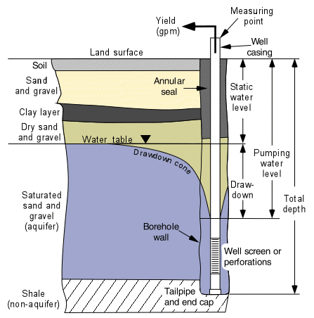
The left side of the drawing shows the geologic setting for this well. The borehole penetrated soil, a near-surface sand and gravel that is separated from the aquifer by a clay layer, and a second sand and gravel. The lower part of the second sand and gravel is saturated and is an aquifer. Below the aquifer the borehole hit shale which is not an aquifer. The water-well driller describes and records the geologic units at the time a well is drilled. Geologic conditions into which wells are constructed vary widely and although those depicted in the drawing are common, they do not represent all conditions encountered by all wells.
Annular seal: The annular seal is the material between the borehole wall and the casing, usually placed near the land surface and is designed to keep surface water and other potential contamination out of the well. Materials commonly used include bentonite (a sticky clay), and neat cement grout (cement and water with no sand).
Aquifer: An aquifer is a geologic unit (sand and gravel, sandstone, limestone, or other rock) that will yield usable amounts of water to a well or spring.
Borehole: the hole drilled to construct a well. Most boreholes for domestic wells in Montana are only slightly larger than the well casing.
Casing: Steel or plastic pipe placed in the borehole to keep it from collapsing. The casing is sealed to the borehole wall near the land surface with the annular seal.
Drawdown: The drawdown in a well is the difference between the pumping water level and the static (non-pumping) water level. Drawdown begins when the pump is turned on and increases until the well reaches "steady state" sometime later. Therefore, drawdown measurements are usually reported along with the amount of time that has elapsed since pumping began. For example, "The drawdown was 10 feet, 1 hour after pumping began."
Drawdown cone: The depression in the water table near the well that is caused by pumping is called the "drawdown cone" or sometimes the "cone of depression". When the well is pumping, water levels are drawn down most near the well and the amount of drawdown decreases as the distance from the well increases. At some distance from the well at any given time there is a point at which the pumping does not change the water table and the drawdown is zero.
Measuring point: Water levels in wells are usually reported as depths below land surface, although the measuring point can be any convenient fixed place near the top of the well. In this drawing the measuring point is the top of the casing. The altitude of the measuring point is commonly recorded so that static water levels can also be reported as altitudes.
Pumping water level: The pumping water level is the distance from the land surface (or measuring point) to the water in the well while it is pumping. The time that the pumping water level was measured is usually recorded also. For example, "The pumping water level was 85 feet below land surface, 1 hour after pumping began."
Screen or perforations: All wells are open to the aquifer so that water can enter the well. Well completions vary from "open hole" in consolidated rock that does not need a casing, to "open bottom" where the only way for the water to enter the well is through the end of the casing. However, many wells have some sort of well screen installed or perforations cut into the casing through which water can enter. The openings must be correctly sized so that water will enter, but sand and other aquifer materials do not.
Static water level: The static water level is the distance from the land surface (or the measuring point) to the water in the well under non-pumping (static) conditions. Static water levels can be influenced by climatic conditions and pumping of nearby wells and are often measured repeatedly to gain information about how aquifers react to climatic change and development.
Tailpipe and end cap: Wells that are completed with well screens may have a tailpipe installed below the screen. The tailpipe provides a place where sand that may enter the well through the screen can settle away from the pump. The end cap forces all water to enter the well through the well screen. Most wells that are completed with perforations will not have a tailpipe.
Water table: The top of the saturated part of a water-table (also known as an unconfined) aquifer. Below the water table, pore spaces (or fractures) in the geologic media are filled with water. Above the water table, the pore spaces are filled with air. An upside-down triangle is often used by hydrologists to indicate the water table.
Total depth: The total depth of the well is the distance from land surface to the bottom.
Yield: The amount of water measured in gallons per minute a well will produce when pumped.
| Ground Water Information Center Online © 1998 - 2024 |
| Staff | Privacy Statement |